


World Heritage Sites XXI
designated by
UNESCO
the World Heritage Committee has inscribed 890 properties on the World Heritage List
The following are some I have visited:
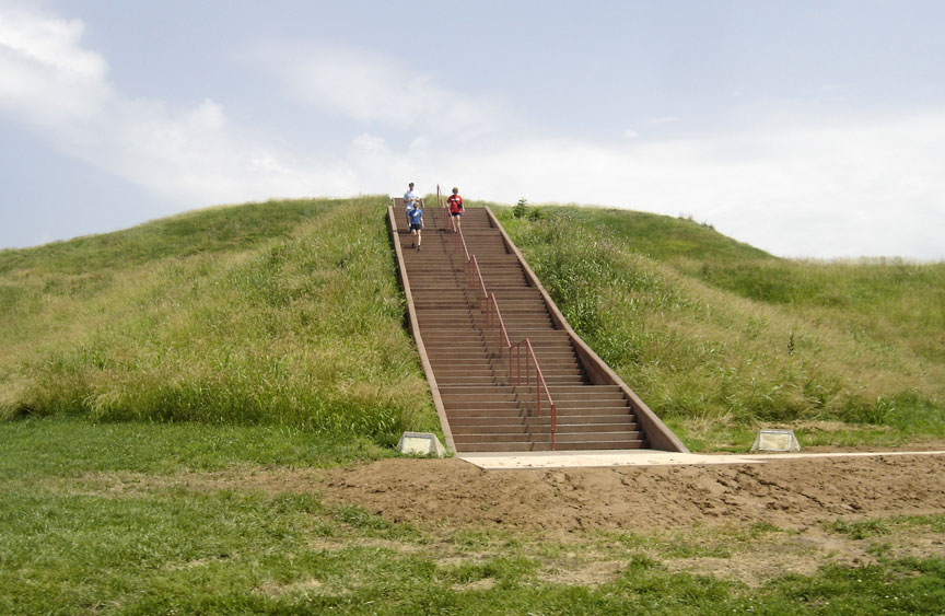
Cahokia Mounds, some 13 km north-east of St Louis, Missouri, is the largest pre-Columbian settlement north of Mexico. It was occupied primarily during the Mississippian period (800–1400), when it covered nearly 1,600 ha and included some 120 mounds. It is a striking example of a complex chiefdom society, with many satellite mound centres and numerous outlying hamlets and villages. This agricultural society may have had a population of 10–20,000 at its peak between 1050 and 1150. Primary features at the site include Monks Mound, the largest prehistoric earthwork in the Americas, covering over 5 ha and standing 30 m high.
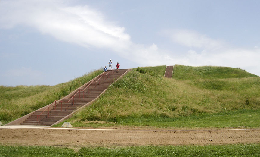
Cahokia Mounds is the largest and earliest pre-Columbian settlement north of Mexico. It was occupied primarily during the Mississippian period (800–1350), when it covered over 1,600 hectares (3,950 acres) and included some 120 mounds. It is the pre-eminent example of a cultural, religious, and economic center of the Mississippian cultural tradition, which extended throughout the Mississippi Valley and the south-eastern United States. This agricultural society may have had a population of 10,000–20,000 at its peak between 1050 and 1150. Cahokia is an early and exceptional example of pre-urban structuring.
Criteria
(iii) Dating from the Mississippian period (800–1350), Cahokia Mounds is the largest pre-Columbian archaeological site north of Mexico, and also the earliest. It is the pre-eminent example of a cultural, religious, and economic center of the prehistoric Mississippian cultural tradition.
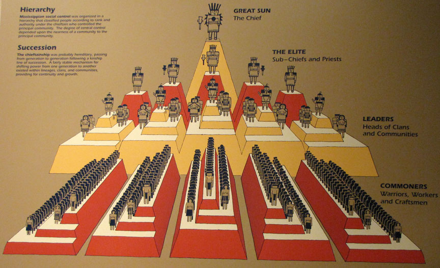
(iv) Cahokia graphically demonstrates the existence of a pre-urban society in which a powerful political and economic hierarchy was responsible for the organization of labor, communal agriculture, and trade. This is reflected in the size and layout of the settlement and the nature and structure of the public and private buildings.
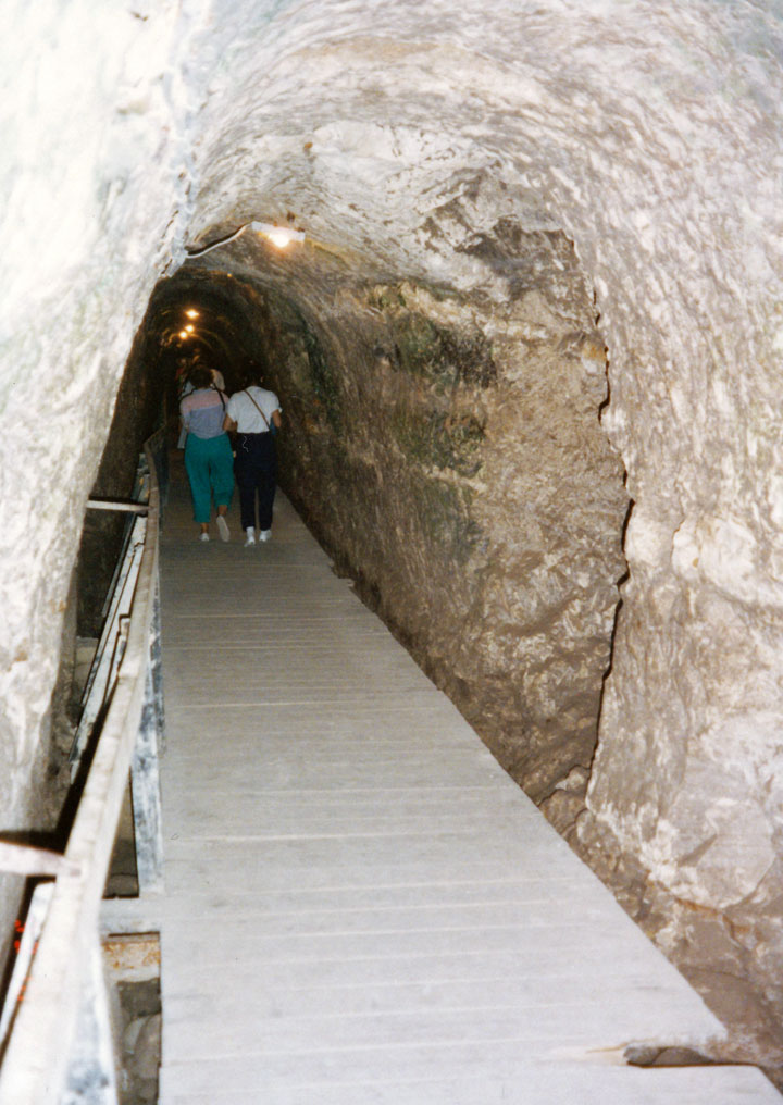
Tel Megiddo water tunnel
Tels (prehistoric settlement mounds), are characteristic of the flatter lands of the eastern Mediterranean, particularly Lebanon, Syria, Israel and eastern Turkey. Of more than 200 tels in Israel, Megiddo, Hazor and Beer Sheba are representative of those that contain substantial remains of cities with biblical connections. The three tels also present some of the best examples in the Levant of elaborate Iron Age, underground water-collecting systems, created to serve dense urban communities. Their traces of construction over the millennia reflect the existence of centralized authority, prosperous agricultural activity and the control of important trade routes.
Historic settlement mounds, known as tels, are
characteristic of the flatter lands of the eastern Mediterranean,
particularly in Lebanon, Syria, Israel and eastern Turkey. Of more than 200
such mounds in Israel, the three sites of Megiddo, Hazor and Beer Sheba are
representative of those that contain substantial remains of cities with
biblical connections, and are strongly associated with events portrayed in
the bible.
The three tels extend across the State of Israel; Tel Hazor in the north,
near the Sea of Galilee; Tel Megiddo 50 kilometres to the south west; and
Tel Beer Sheba near the Negev Desert in the south.
The three sites reflect the wealth and power of Bronze and Iron Age cities
in the fertile biblical lands. This was based on, and achieved through, a
centralized authority that had control of trade routes to the north east and
south; connecting Egypt to Syria and Anatolia to Mesopotamia, and the
creation and management of sophisticated and technologically advanced water
collection systems. Together, these tels reflect the key stages of urban
development in the region.
They are also representative of the large, multi-layered occupation of
single sites that persisted for several millennia until the 6th century BCE,
and particularly reflect in their final flowering the formative stages of
biblical history from the 12th to 6th century BCE. With their impressive
remains of palaces, fortifications and urban planning, they offer key
material manifestations of the biblical epoch.
The early Bronze Age temple compound at Megiddo is unparalleled for its
number of temples, the continuity of cult activity and the record of ritual
activity. At Hazor, the ramparts are said to be the best example in the area
from southern Turkey to the north of the Negev in Israel. The late Bronze
Age palace is the most elaborate in Israel, and one of the best in the
Levant. For the Iron Age remains, the elaborate town plan of Beer Sheba and
the orthogonal plan of Megiddo have few parallels in the Levant.
All three tels have impressive remains of their underground water catchments
systems, which demonstrate sophisticated and geographically responsive
engineering solutions to water storage.
Boyana church
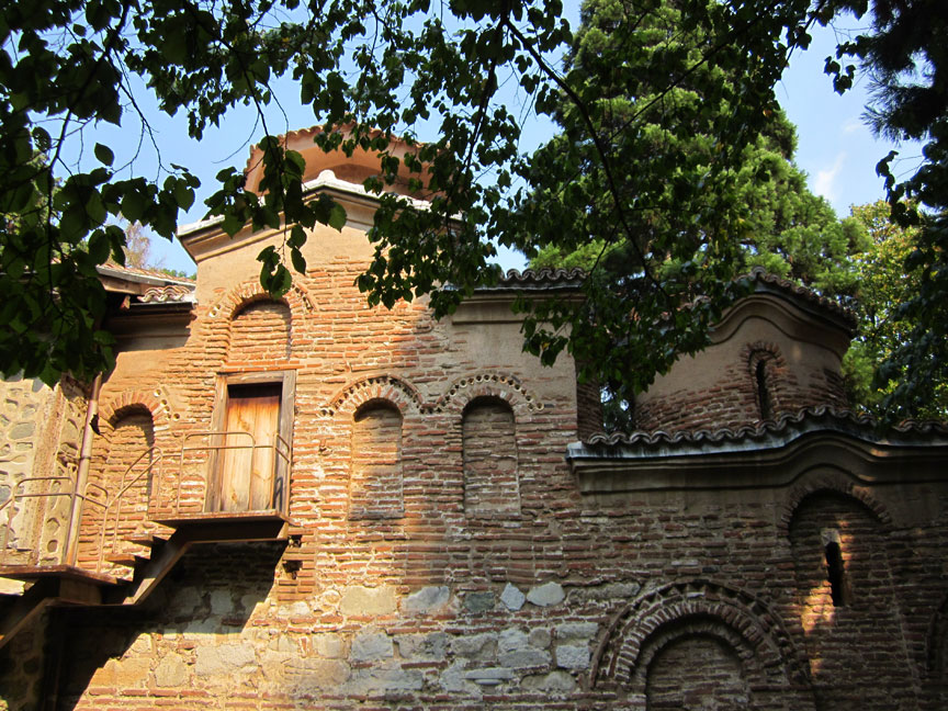
Located on the outskirts of Sofia, Boyana Church consists of three buildings. The eastern church was built in the 10th century, then enlarged at the beginning of the 13th century by Sebastocrator Kaloyan, who ordered a second two storey building to be erected next to it. The frescoes in this second church, painted in 1259, make it one of the most important collections of medieval paintings. The ensemble is completed by a third church, built at the beginning of the 19th century. This site is one of the most complete and perfectly preserved monuments of east European medieval art.
There are several layers of wall paintings in the interior from the 11th, 13th, 15-17th and 19th centuries which testify to the high level of wall painting during the different periods. The paintings with the most outstanding artistic value are those from 13th century. Whilst they interpret the Byzantine canon, the images have a special spiritual expressiveness and vitality and are painted in harmonious proportions.
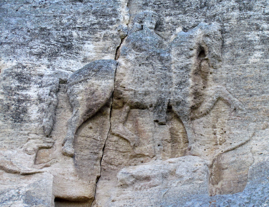
Madara Horseman
The Madara Rider, representing
the figure of a knight triumphing over a lion, is carved into a 100-m-high
cliff near the village of Madara in north-east Bulgaria. Madara was the
principal sacred place of the First Bulgarian Empire before Bulgaria’s
conversion to Christianity in the 9th century. The inscriptions beside the
sculpture tell of events that occurred between AD 705 and 801.
The Madara Rider is a unique relief, an exceptional work of art, created
during the first years of the formation of the Bulgarian State, at the
beginning of the 8th century. It is the only relief of its kind, having no
parallel in Europe. It has survived in its authentic state, with no
alternation in the past or the present.
It is outstanding not only as a work of Bulgarian sculpture, with its
characteristically realist tendencies, but also as a piece of historical
source material dating from the earliest years of the establishment of the
Bulgarian state. The inscriptions around the relief are, in fact, a
chronicle of important events concerning the reigns of very famous Khans:
Tervel, Kormisos and Omurtag.
The Thracian tomb of Kazanlak is a unique aesthetic and artistic work, a masterpiece of the Thracian creative spirit. This monument is the only one of its kind anywhere in the world. The exceptionally well preserved frescos and the original condition of the structure reveal the remarkable evolution and high level of culture and pictorial art in Hellenistic Thrace.
Thracian Tomb of Sveshtari, Bulgaria
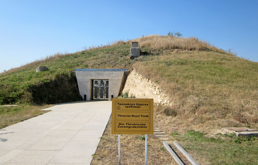
Thracian Tomb of Sveshtari
The discovery in 1982 of the Thracian tomb of Sveshtari was one of the most spectacular archaeological events of the 20th century. The tomb itself is a unique artistic achievement with its half-human, half-vegetable caryatids enclosed in chitons in the shape of inverted palmettes. The fact the original polychromy has been preserved with its ochre, brown, blue, red and lilac shades adds to the bewitching charm of an expressive composition where the anthropomorphic supports conjure up the image of a choir of mourners frozen in the abstract positions of a ritual dance. The tomb is an exceptional testimony to the culture of the Getae, a Thracian people living in the north of Hemus, in contact with the Greek and Hyperborean worlds according to ancient geographers.
The tomb is located in a region declared an archaeological reserve, near the town of Razgra between the villages of Malak Porovetz and Sveshtari in Isperih municipality, in the river Krapinetz canyon and on the hills around. The time when the Sveshtari tomb was built (mid-3rd century BC) coincided with the period of a great political, economic and cultural upsurge of the Thracian tribe of the Getae. The rich decoration and perfect architecture of the tomb demonstrate the political power of the ruler.
![]() Under
a tumulus 11.5 m high and roughly 70 m in diameter, geophysical prospecting
revealed, to the south-east, the monumental entrance to a hypogeum of
exceptional interest, including a dromos, an antechamber, and two rectangular
funeral chambers. The layout of this Thracian king's tomb, which is very
different from that of Thracian tombs with cupolas such as that of Kazanlak,
fits a Hellenistic model to be found in Macedonia, Asia Minor and Egypt. The
tomb of Sveshtari is, however, unique in its architectural decor and in the
specific character of funeral rites revealed by the excavation.
Under
a tumulus 11.5 m high and roughly 70 m in diameter, geophysical prospecting
revealed, to the south-east, the monumental entrance to a hypogeum of
exceptional interest, including a dromos, an antechamber, and two rectangular
funeral chambers. The layout of this Thracian king's tomb, which is very
different from that of Thracian tombs with cupolas such as that of Kazanlak,
fits a Hellenistic model to be found in Macedonia, Asia Minor and Egypt. The
tomb of Sveshtari is, however, unique in its architectural decor and in the
specific character of funeral rites revealed by the excavation.
The tomb consists of a corridor (dromos) and three square chambers: antechamber, lateral chamber, and main burial chamber covered by a semi-cylindrical vault. The plan of the building provides a new interesting example in Thracian building practice. The decoration of the tomb is executed in the spirit of the contemporary Hellenistic architecture. Its entrance is flanked by two rectangular columns (antae). Above them there is an architrave plate with a frieze in relief, consisting of stylized bovine heads (bucrania), rosettes and garlands. Ten beautiful female figures with hands raised high like caryatids are impressive. The figures are about 1.20 m tall, presented frontally, wearing long sleeveless dresses (chitons) tied with a thin belt below the breasts.
Two funerary beds, human bones and grave offerings were discovered in the central chamber. From the scattered stone details it was possible to reconstruct the facade of the tomb (aedicula), consisting of pilasters, cornice and a pediment, and closed with three stone doors. Being situated in front of the large funerary bed as a symbol of the boundary between life and death, the aedicula isolated the grave of the deified ruler (the most sacral part of the tomb) from the rest of the place. In the centre of the composition the goddess is offering a gold wreath to the ruler, depicted as a horseman facing her. On both sides of them there are processions of servants and armour-bearers carrying different gifts in their hands.
The layout of the central chamber which contained two stone funeral beds and an aedicula imitates the arrangement of a peristyle house: five half-columns and ten sculpted feminine caryatids in high relief on limestone flagstones support the architrave barrel-vaulted Doric frieze with its triglyphs and metopes spanning the room at mid-height.
In the north-west lunette, on the wall opposite the entrance, there is a painting depicting the deceased as hero, who, in the presence of several protagonists, is advancing on horseback towards the central figure of a deity extending a laurel wreath. Skeletal material found during excavation bears witness to the horse sacrifices that accompanied the funerary rites.
Ancient City of Nessebar, Bulgaria
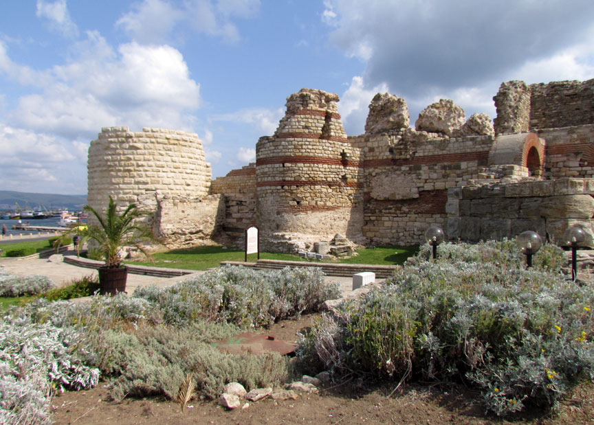
Nesebar
Situated on a rocky peninsula on the
Black Sea, the more than 3,000-year-old site of Nessebar was originally a
Thracian settlement (Menebria). At the beginning of the 6th century BC, the city
became a Greek colony. The city’s remains, which date mostly from the
Hellenistic period, include the acropolis, a temple of Apollo, an agora and a
wall from the Thracian fortifications. Among other monuments, the Stara
Mitropolia Basilica and the fortress date from the Middle Ages, when this was
one of the most important Byzantine towns on the west coast of the Black Sea.
Wooden houses built in the 19th century are typical of the Black Sea
architecture of the period.
The Ancient city of Nessebar is a unique example of a synthesis of the
centuries-old human activities in the sphere of culture; it is a location where
numerous civilizations have left tangible traces in single homogeneous whole,
which harmoniously fit in with nature. The different stages of development of
its residential vernacular architecture reflect the stages of development of the
architectural style on the Balkans and in the entire East Mediterranean region.
The urban structure contains elements from the second millennium BC, from
Ancient Times and the Medieval period.
The medieval religious architecture, modified by the imposition of the
traditional Byzantine forms, illustrates ornamental ceramics art, the
characteristic painted decoration for this age. The town has served for over
thousands of years as remarkable spiritual hearth of Christian culture.
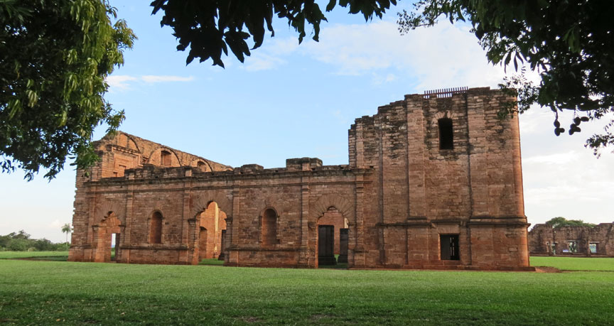
Jesús de Tavarangue Ruins
The Society of Jesus established
itself in the region known as the Guayrá in 1588, by permission of Philip II.
One of its objectives became the protection of the Indians against the abuses of
the colonial encomienda system of tribute or labour, which reduced them to a
condition of virtual slavery; at the same time they would be brought into the
Christian Church and educated into a sedentary form of life. Following the
granting of the frontier zone of Paraguay to the Jesuits in 1609 by the Spanish
Crown, they moved into the lands of the Guaraní people in the Rio de la Plata
basin, where they created reducciones (settlements), each with its mission.
There were 30 in all, 8 in latter-day Paraguay, 15 in Argentina, and 7 in
Brazil.
La Santísima Trinidad, the most ambitious of these missions and the capital of
the Guayrá, was built in 1706, the work of the noted Jesuit architect Juan
Bautista Primoli. It was constructed in stone with a fine dome and elaborated
decoration.
The reducción of Jesús de Tavarangue was founded in 1685, but moved some years
later to its present site, when the mission was built.
Santos Cosme y Damián, founded in 1632 on Brazilian territory, moved to its
present site in 1740.
La Santísima Trinidad de Paraná has the best preserved urban structure: Plaza
Mayor, main church (crypt), small church, college and cloister, cemeteries,
kitchen gardens, belfry, native houses and workshops.
The ruined church of Jesús de Tavarangue retains much of its imposing
appearance, but only one room of the college survives. There are significant
remains of the urban structure, including the Plaza Mayor, native houses and
cemeteries.
The church of Santos Cosme y Damián was never finished. However, it has
continued to serve as a place of worship. Other remains also survive, including
one of the wings of the college, the cemetery, and contemporary Indian houses.
All three are in essence archaeological sites, consisting of ruined building and
occupation layers, and so their authenticity is not in question. The church of
Santos Cosme y Damián, being in current use, has some more recent features, but
restoration interventions have respected the ancient fabric and materials.
La Santísima Trinidad, the best preserved of the three, is of great symbolic
importance, because its decoration reflects the spirit of its conception, with
its fusion of Christian and native artistic elements. Santos Cosme y Damiàn is
important because, in addition to its historical significance, it has retained
its role as a centre of worship for the village and district in which it is
located.
Jesuit Missions of the Guaranis: San Ignacio Mini, Santa Ana, Nuestra Señora de Loreto and Santa Maria Mayor, Argentina
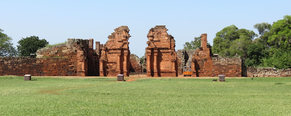
San Ignacio Miní
The remains of these Jesuit missions
are outstanding examples of a type of building and of an architectural ensemble
which illustrate a significant period of the history of Argentina and Brazil.
The ruins of Saõ Miguel das Missões in Brazil and those of San Ignacio Miní,
Santa Ana, Nuestra Señora de Loreto and Santa María la Mayor in Argentina lie in
the heart of a tropical forest. They are impressive remains of five Jesuit
missions, built in the land of the Guaranis during the 17th and 18th centuries.
All these Guarani reducciones (settlements) are laid out on the same model: the
church, the residence of the Fathers, and the regularly spaced houses of the
Indians are laid out around a large square. However, each of the reducciones is
characterized by a specific layout and a different state of conservation.
San Ignacio Miní, founded in 1611, was moved on two successive occasions,
settling in its present site in 1696. It incorporates important monumental
remains: churches, residence of the Fathers, schools. The ruins are accessible
and in a relatively good state of preservation. It is the most eminent example
of a reduccion preserved on Argentinean territory.
Santa Ana, founded in 1633 on the Sierra del Tape, was removed in 1638 to the
bank of the Paraná river and once more to its present site, 45 km from Posadas.
The ruins of the church, which are accessible by a monumental stairway, emerge
from a forest site. It resisted pillage following the expulsion of the Jesuits
in 1767.
Nuestra Señora de Loreto, founded in 1610, was moved in 1631 to its present site
53 km from Posadas. The mission included a printing-press. The church and the
Fathers' house were built by Brother Bressanelli, as at San Ignacio Miní. The
ruins of the Indian village have been partially cleared of vegetation
Santa María la Mayor, founded in 1626, was moved to its present site in 1633.
Not far from the ruins of the church, important remains of the residence of the
fathers are still standing.
Saõ Miguel, founded on the site of the Itaiaceco in 1632, was transferred first
to Concepción, and then in 1687 to its present site on the banks of the Piratini.
Of the village not one building remains intact; all that are visible are the
foundations of the Fathers' residence, the school, and the walls of the
cemetery, along with some vestiges of Indian habitations. In a site that is
periodically invaded by vegetation are found the ruins of the church attributed
to Father Gian Battista Primoli, a Jesuit architect of Milanese origins, well
known for his work in Buenos Aires, Córdoba and Concepción. This Baroque church,
finished in 1750, was ravaged 10 years by fire. It was restored in a rather
summary manner during the years which preceded the definitive expulsion of the
Jesuits in 1768.
As of 4/1/2012 I have visited and
taken photos of
309 of the 936 World Heritage Sites in 149 countries.


