


Calcutta
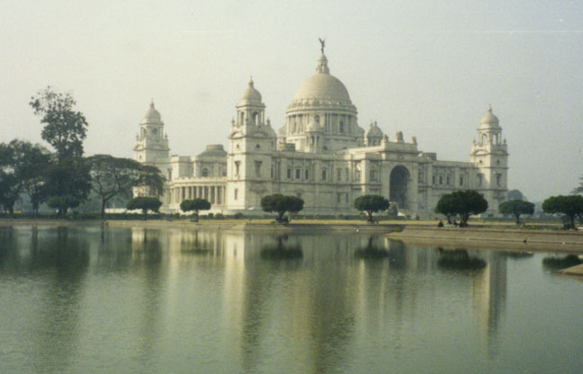
Queen Victoria Memorial (1921)
Kolkata or Calcutta, city in eastern India and capital of Bangla State, situated on the banks of the Hugli River (Hooghly)(a tributary of the Ganges River). Kolkata lies about 100 km (about 60 mi) north of the Bay of Bengal and about 70 km (about 45 mi) west of Bangladesh. It is the hub of India’s second most populous metropolitan area (after Mumbai, formerly known as Bombay) and is the chief commercial, financial, and manufacturing center of eastern India.
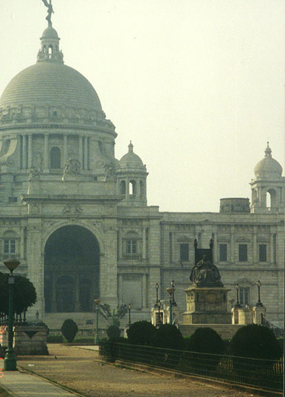
statue of Queen Victoria in front of building
Kolkata was founded by the English East India Company in the late 1600s and named for Kalikata, a local rice-growing village with a temple of the goddess Kali. It served as the capital of British India from 1773 through 1911. During the British era, administrative offices and a British-style university, the University of Kolkata, were established. Jute mills and other industries along the Hugli River both north and south of the city also contributed to Kolkata’s growth and eventually gave rise to major urban development, creating the Kolkata metropolitan area.
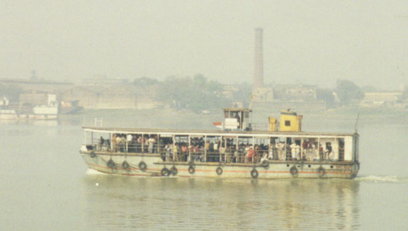
transport on the Hugli river
Kolkata is located only about 1° south of the tropic of Cancer, close to sea level in a formerly swampy area. It lies in a monsoon region, with most of its average annual rainfall of 1625 mm (64 in) falling from June through September. Though winters are mild, with an average January temperature of 19° C (67° F), the temperature sometimes dips to 10° C (50° F). From March through September, Kolkata is hot and humid, with an average July temperature of 29° C (85° F); in the months of May and June the temperature may rise as high as 38° C (100° F).
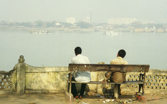
along the river
The city of Kolkata covers an area of 185 sq km (71 sq mi). It lies near the
southern third of the metropolitan area, which is known as the Kolkata
Metropolitan District (KMD). The CMD covers an area of 1246 sq km (481 sq mi)
and is comprised of nearly 500 units of local government, including three
municipal corporations and 29 municipalities. Roads and railways make up the
main traffic arteries, and a bypass road has been built east of the city to
facilitate through traffic. The Hugli River runs through the CMD. As during
colonial times, industries are located on both banks of the Hugli and along
railroad lines. Financial, administrative, and trade activities are concentrated
in the city’s Central Business District (CBD), which lies just east of the Hugli
River, and its immediate surroundings. The center of the CBD covers an area that
includes Kolkata’s major landmark, the Maidân, which is a large park containing
many fine drives, a golf course, a racecourse, cricket grounds, several soccer
fields, and the historic new Fort William (completed in 1781) of the English
East India Company. The residential settlements follow a linear pattern along
highlands provided by Hugli River levees and on the intervening levees of old,
dried up rivers. Between and beyond the levees to the east and west of the Hugli
are the lowlands, which are prone to flooding during the rainy months; parts of
the lowlands have been filled or drained for additional settlements. Low-income
settlements are located in the lowlands. Such slums are found all over, but with
a concentration at the fringes of the urban areas. Slum structures are
characterized by flimsy materials, lack of underground sewerage, unsanitary
conditions, and tenements of one-room apartments.
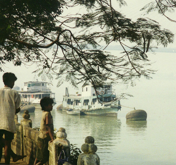
river transport
Architectural monuments in Kolkata date mostly from colonial times. After an
attack on the old Fort William (situated east of Dalhousie Square) in 1756 by
Siraj-ud-Dawlah, the Muslim ruler of Bengal, a new, sturdier Fort William was
built about 1.5 km (about 1 mi) south of the old site near the Hugli River in
the Maidân. At the heart of the CBD lies BBD Bagh or the former Dalhousie
Square. On the north side of the square is the Writers’ Building (1880), which
houses the state government ministries. To the west of the square is the General
Post Office, which features a high reinforced concrete dome. Two blocks
southwest of the square is the Gothic-style High Court (1872), with a 55-m
(180-ft) high tower that is modeled after the Cloth Hall of Ieper, Belgium. The
massive Victoria Memorial, completed in 1921, sits at the southern end of the
Maidân; it is built in a Renaissance design with Indian influences. Dakshineswar
Temple, built in the 19th century, is north of the city limits on the Hugli
River; its design is influenced by the thatched bamboo huts of southern Bengal.
A building of similar design located just north of Kolkata on the river is Belur
Math, which houses a monastery and the headquarters of the Ramkrishna Mission.
Parasnath Jain Temple (1867), Marble Palace (1835), and Nakhoda Mosque (1926)
are other architectural landmarks in the Kolkata area.
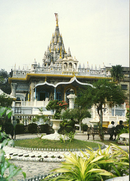
Sitambara Jain temple
Other places of interest in Kolkata are the fashionable Jawaharlal Nehru
(formerly Chowringhee) Road, the city’s main thoroughfare; the Raj Bhavan (1802;
formerly called the Government House), the state governor’s residence; the
Indian Museum (1875), which contains noted displays on archaeology and natural
history; and the Birla Industrial and Technological Museum. The Botanical
Gardens (1786) in Hâora (or Howrah), Kolkata’s twin city, features many tropical
plants in addition to a famous banyan tree, the branches of which spread 381 m
(1250 ft) in circumference.
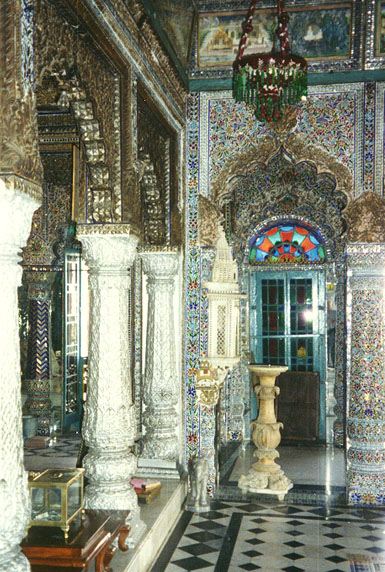
interior of Jain temple
As the capital of British India and home to the fertile agricultural and
mineral-rich land of eastern India, Kolkata was one of the first areas of India
to develop industrially. The first jute and paper mills of India were started in
the Kolkata area in the 1800s. By 1921 nearly 35 percent of India’s industrial
workers were located in Kolkata. However, Kolkata began to lose its industrial
leadership after India gained its independence in 1947. One cause was the loss
of Kolkata’s raw jute supply when Bengal was divided into Bangla and East
Bengal, with East Bengal becoming part of Pakistan. Competition in jute
manufacturing from East Bengal (later East Pakistan, now Bangladesh) further
hurt Kolkata’s jute industry. Competition and slow growth also hit other
traditional manufacturing areas, such as heavy engineering, rubber, and paper.
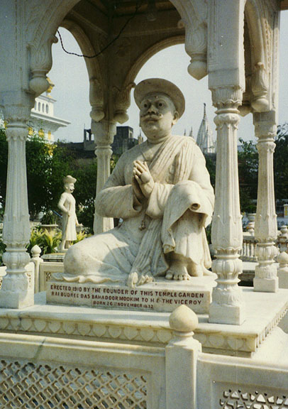
founder of the temple gardens
Other factors that have hurt metropolitan Kolkata’s industrialization include a 1977 ban imposed by the Indian government on new licenses of large-scale industrial units in the large metropolises; labor troubles since the end of 1960s; pro-union attitude of the state government; severe power shortages; limitations on raw materials; and shortage of capital. Moreover, a slow depletion of water volume in the Hugli River limited the size of ships at Kolkata’s docks, causing Kolkata to lose its status as the premier port city of India. The water supply problem has been resolved to some extent by diverting water from the Ganges River to the Hugli, and by constructing a diversion canal and the Farakka barrage, which increased the depth of the channel, in 1976. A deep port at Haldia, about 65 km (about 40 mi) south of the Kolkata, has also been established. Ships arriving at Kolkata from the Bay of Bengal travel only when the river is in high tide, escorted by specially trained Hugli pilots; additionally, the river channel is constantly dredged. Few new major industries came into the CMD in the 1970s and 1980s, but in the mid-1990s the state attracted some large-scale capital investments both from native and foreign sources because it relaxed its anti-capitalist stance.
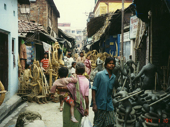
workers in the crowded quarter
devoted to making festival figures
Although Kolkata’s poor economic factors have caused it to lose its designation as India’s largest commercial and banking center, it is the headquarters of many native business firms, banks, and international corporations. One of India’s largest companies, Birlas, is headquartered in Kolkata. As the remaining agricultural land has been lost to urban development, the percentage of Kolkata’s workers employed in various fields has changed. As of 1991, 58 percent of workers were employed in services, 40 percent in industry (including 4 percent in construction), and 2 percent in agriculture. The agricultural and industrial sectors experienced the greatest declines. The majority of people employed in the service sector are involved in trade and commerce, in jobs that generally offer little pay or security. Most of this group works in retail or small-scale trading establishments, often without a roof, either in a family business or employed by a small investor. Kolkata still continues to attract surplus labor from surrounding areas, increasing the population over and above the city’s natural birthrate increase.
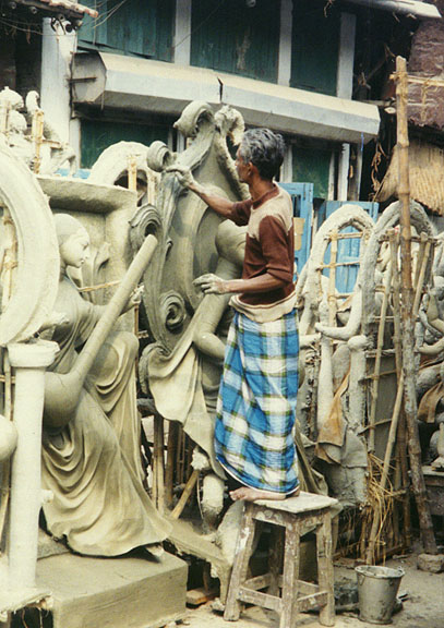
crafting a figure
Public transportation, such as buses, trams, trains, and subways, are the principal means of transport in the Kolkata metropolitan area. Buses operate throughout the area, and trains have north-south lines with a few east-west connections. There are two major train terminals: Sealdah in the east central part of Kolkata and Hâora across the river from the Central Business District. Electric trams operate in Kolkata proper. The aging buses, trains, and tram cars suffer from overloading, creating uncomfortable rides. Subway construction started in 1972 and became operational with 7 km (4.3 mi) of line in 1984. By 1995 all of the subway’s 16.4-km (10.2-mi) route from Dum Dum to Tolluguye was completed. The subway carries an estimated 25 percent of Kolkata’s 7 million commuters. Cycle rickshaws are not allowed in the city of Kolkata, but they are common in the metropolitan area. Hand-pulled carts are used for short-distance cargo hauling. Private automobiles, extensively used in Kolkata and Hâora, are increasing in numbers and are owned by the wealthy. The streets of Kolkata remain congested with taxis, private automobiles, buses, slow-moving trams, and hand-pulled carts. Air pollution caused by automobiles, buses, and industrial emissions is severe. Kolkata’s international airport at Dum Dum provides service for both national and international airlines.
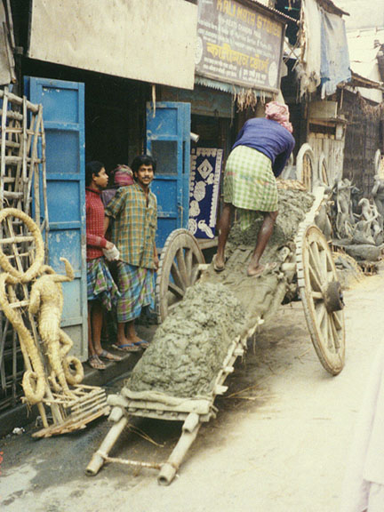
delivering earthen working material
According to the 1991 census, Kolkata had a population of 4,309,819, with an
extremely high population density of 23,720 persons per sq km (61,970 persons
per sq mi). The metropolitan area had a population of 11 million and a density
of 8761 persons per sq km (22,661 persons per sq mi). The growth rate of the
metropolitan area population was 18.7 percent between 1981 and 1991, down from
the 1971 to 1981 growth rate of 23.9 percent. The population of the city of
Kolkata grew more slowly than the CMD. Since India’s first census in 1872,
Kolkata has generally been India’s largest city, although in 1991 it lost that
status to Mumbai. Of the total population of Kolkata’s metropolitan area in
1981, more than 30 percent lived in slums; many other Kolkata residents are
so-called pavement dwellers (homeless). Mother Teresa, a Roman Catholic nun who
received the Nobel Peace Prize in 1979, founded the Missionaries of Charity in
1950 to help the poorest of the poor in Kolkata and all over the world.
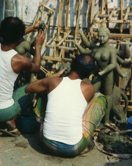
shaping a female goddess image with the earth material
Kolkata is the home of the University of Kolkata (founded in 1857) and Jadavpur University (1955). Rabindra Bharati University (1962), devoted to fine arts, is housed at the former residence of Bengali poet and Nobel Prize winner Rabindranath Tagore. Part of the Tagore residence is now a museum. Another Nobel laureate, Sir Chandrasekhara Venkata Raman, who received the Nobel Prize in physics in 1930 for his discovery of the Raman effect on light, worked and researched in Kolkata for a long period. Sarat Chandra Chatterjee, a highly regarded Bengali fiction writer of the early 20th century, lived in nearby Hâora. Ram Mohan Roy, sometimes called the father of modern India, began his social reform for abolition of suttee (burning to death of a wife with her deceased husband) in Kolkata. He also founded Brahmo Samaj, a modern Hindu religious sect, in the city in 1828. More than 70 percent of Kolkata’s population were literate in 1991. The literacy rate is higher for men, who generally receive more education than women; for every three men only two women are literate. Several languages are spoken in Kolkata, including English. Bengali speakers constitute 60 percent of the city’s population, and there are Hindi (23 percent), Urdu (11 percent), and Oriya (1.3 percent) speakers as well. After British India was partitioned into India and Muslim Pakistan in 1947, a large number of Muslim residents migrated from Kolkata to East Pakistan, while many Hindu refugees arrived in the city from East Pakistan. Today Hindus constitute 83 percent of the city’s population while Muslims make up 14 percent; the rest of the population is comprised of small groups such as Christians, Jains, and Sikhs.
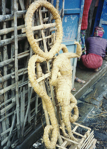
straw figure reinforcement
Modern Kolkata was founded in 1690 by British trader Job Charnock as a trading
post of the English East India Company. In the mid-17th century the Portuguese
had a trading outpost in the area at Sutanuti, followed by the Dutch, who
constructed a diversion canal at the bank of the Hugli River, near the present
Central Business District. The old Fort William was built to protect the English
post in 1696. The city became famous in 1756, in England particularly, when
Siraj-ud-Dawlah, a Bengal ruler, captured the fort and, according to British
historians, stifled to death 43 British residents in a small guardroom called
the Black Hole of Kolkata. The city was recaptured by the British under Robert
Clive in 1757. The English initially built an intricate transport network
through the Hugli-Ganges water system, but it was the railroads, introduced in
the 1850s, that successfully established connections with the hinterland and the
rest of India. The city eventually had the largest concentration of trading
establishments in India, and a Western-style business district evolved by the
end of the 19th century. The colonial city maintained a strict division between
the crowded and ill-planned native quarters to the east and north of the Central
Business District, and the spacious and well-planned quarters where the
Europeans lived in the south and southeastern parts of the old city. After
independence, the former European quarters were either turned into residences of
the Indian rich or, as in the Park Street area, into commercial areas.
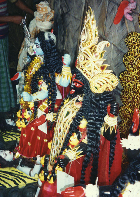
completed festival figures
With the dominance of leftist political parties in the Bangla state government
in the late 1960s, Kolkata’s municipal government also came to be controlled by
Communists. Corruption and bureaucratic inefficiencies caused city services to
deteriorate under this government, and today Kolkata is one of the most
ill-serviced and chaotic metropolises of the world.
Contributed By: Ashok K. Dutt for Microsoft Encarta
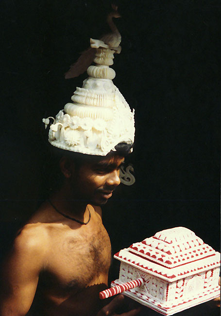
in festival costume
![]()


![]()